Click on Images to Enlarge
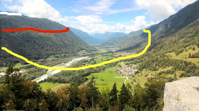
You are positioned on the ruins of Tolmin Castle in presented day Slovenia looking to the northwest. The river in the foreground is the Soca, formerly known as the Isonzo. Exactly 8 miles in the distance is the river town of Kobarid, formerly Caporetto. In October 1917 Italian, German and Austrian troops were deployed across the river basin and up into the mountains rising on either side. Here, one of the most decisive breakthroughs in all of military history would take place in the opening of the Battle of Caporetto. A second breakthrough, similar in execution and impact, took place concurrently in far northern sector of the battleground, but in this article we will restrict ourselves to what happened here in the southern section around the town of Tolmin.
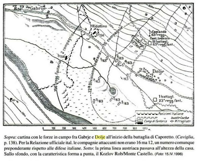
This map shows the deployment of the Italian 12th Division astride the river on the morning of 24 October 1917. The map's orientation is 90 degrees counter-clockwise from the photo. Tolmin Castle is not shown, but would be just off the map to the immediate right of the village of Dolje. The 12th Division was deployed in three thin lines, just strong enough to slow down an enemy assault. The river basin was thought by the Commando Supremo to be an excellent "kill zone" for the artillery deployed on the surrounding hills and mountains. This kill zone would not come about on the morning of the attack, however, because of the suppressive power of the awesome artillery and gas assault of the attackers and the rain and dense fog that obscured the vision of all the observers in the valley that morning. Neglecting the effect of bad weather was a major oversight of the Italian high command that, but it was not the greatest flaw in their defensive preparations.
The decisive problem for the Italian soldiers that day was that their commanders had deployed them in a doubly flawed fashion. In places, the three lines of the forces were too distant to support each other, and in others, the lines converged and made it possible for a powerful thrust to breakthrough all three positions with a single attack.
In this version of the photo, the three Italian lines are superimposed on the terrain: yellow for 1st, red for 2nd, and white for 3rd. Reserve formations are far to the west, behind the mountains shown on the extreme left. Austrian forces are on mountains to the right, German divisions are concentrated around Tolmin, in the foreground and to the left of the picture. Note that the Italian 1st line goes right up into the high mountains. At the outbreak, the Austrians attacked these troops (there were tens of thousands of the best Italian soldiers, including elite arditi and alpini, on the mountainside) from the peaks above to pin them down. Meanwhile, German troops attacked down both sides of the river and were half-way to Caporetto before the Italians knew what hit them. There would be no relief for the now surrounded men on the mountains. No one could see what was going on, and even without the fog, there was no possibility of sending reinforcements from the distant 2nd line, down one mountain and up another to relieve the trapped men. Within the first hour of the ground assault in just this part of the battlefield, Italy has suffered its greatest defeat of the war, and the catastrophe has just begun to unfold.
Let's look now at what's happening on the left side of the photo. German soldiers, including the inimitable Lt. Erwin Rommel, crashed through the Italian 1st line and moved against the 2nd line, capturing its strong points and observation posts in detail. The Italian reserves, miles off the left side of the photo, were too far to the rear to arrive in a timely way, and there was another nearer dynamic unfolding that soon occupied their attention. About two miles to the left of our photograph, on the slopes of a steep mountain named Mte. Jeza, the three Italian lines came dangerously close to one another. At this point another breakthrough took place that allowed the opposition to circle around the 3rd Italian position, (white line) along the high peaks above the river. Every Italian position on the 1st, 2nd or 3rd line could be rolled up from the rear. With a matching situation eventuating from the northern breakthrough, Commando Supremo realized its entire front was collapsing and gave the orders to withdraw and retreat deep into Italy. German and Austrian units were in full pursuit.


That's really helpful - and one gorgeous photo!
ReplyDeleteThis is an excellent use of a modern day photo marked to show the Italian defensive lines. It makes it much easier to understand the text description of the battle. I enjoyed reading the article.
ReplyDeleteExcellent view!
ReplyDelete